از برنامه APKPure استفاده کنید
نسخه قدیمی APK TcpGPS Demo را برای اندروید بگیرید
Full solution for surveys and setting out of linear works with GNSS
This application allows the user to survey and stake out topographic data with professional GNSS receivers, integrated or connected through Bluetooth.
In smartphones, you can switch quickly among the display modes of every features, whilst in tablets the map and all numerical data are shown simultaneously. An artificial voice system gives information to users about changes in position accuracy, points surveyed or staked out, communication failures, etc.
BASE MAPS
ESRITM base maps with global coverage are used, which can be displayed in street, satellite or topographic mode.
DXF or shape cartography files can be also loaded, as well as web map services (WMS) provided by official authorities.
The project is organised in layers, whose symbology, visibility and visualization order can be changed at any time.
RECEIVER CONTROL
Information about the quality of position, number of satellites detected and used and status of the Bluetooth connection for external receivers are displayed at all times.
Detailed information about current position is displayed, including geographic and projected coordinates and real time graphics with the satellites constellations, including GPS, GLONASS, Galileo and BeiDou, and the Satellite Based Augmentation System (SBAS).
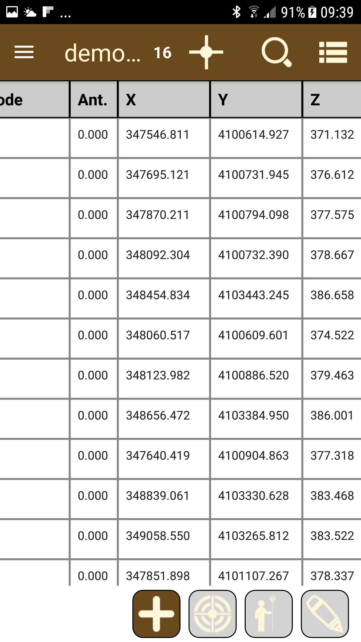
SURVEY
The application allows the survey of topographic points by simply touching a button. For every button, all raw data are stored: date and time, number of point, geographic and projected coordinates, position mode, estimated accuracy and antenna height. They can also be related with a picture, voice note and comments.
The user can define his own codes, both point (trees, poles, manholes, etc.) or linear features (paths, sidewalks, high and low slope lines, etc.). If used the points and lines will be drawn automatically in their layers with desired symbology.
Continuous survey allows to record points automatically giving a distance or time interval. If used with linear features the vertices will be joined, and you can get easily the perimeter or area measured. Other utilities allow us to calculate 2D or 3D distances and elevation difference between two points, or the area among several points.
Points can be exported to text, DXF, GML or KML formats. In addition, all data captured can be automatically synchronized with Google Drive, so that it will not necessary to come back to office to save the information.
STAKE OUT
Points to be staked out are imported from a text file, and they can be selected on the map or filtered by code. The user can switch interactively among several modes:
- Map, indicating clearly the current and target position and giving orientation with respect to the North, movement or last stored point.
- Compass, if tablet or smartphone have magnetometer, giving correct orientation and showing the distance to target.
- Dartboard, appropriate when target is close, showing the current position and relative distance to target.
In all cases an optional voice system informs the user about proximity to target, giving instructions in natural language like “15 meters ahead and 2 meters to the right”. Horizontal and vertical tolerances are configured along with other parameters.
The symbology of staked out points is clearly different from the rest, and the information can be consulted in report format, switching among raw, coordinate and stake out data.
COORDINATE SYSTEMS
The program includes the EPSG geodetic parameter dataset, allowing to work with different coordinate reference systems organized by countries.
(1) Esri and the Esri Logo are licensed trademarks of Environmental Systems Research Institute, Inc.
Last updated on 09/08/2019
Bluetooth management connection improved.
Notification of invalid tolerances in setting out.
Setting out mode respect to the sun.
Search of points by number for setting out.
New information shown in map: scale and current location.
Export setting out point data.
New drivers for GNSS receivers.
Changes in icons and layouts.
Issues and bugs and bugs.
آخرین نسخه
![]() 1.4.2
1.4.2
بارگذاری شده توسط
Asem Salah
نیاز به اندروید
Android 4.0.3+
دسته بندی
گزارش


بیشتر بیابید آنچه که می خواهید آسان تر، سریع تر و ایمن تر است.

TcpGPS Demo
1.4.2 by APLITOP
09/08/2019