Use APKPure App
Get Trimble SiteVision old version APK for Android
Reimagine your 2D and 3D data with augmented reality!
Trimble® SiteVision® is a real-time, in-field visualization software for collaborating on project progress and detecting design changes or conflicts. Enable your team to detect errors, observe omissions, and visually collaborate to resolve them.
Work with SiteVision indoors, or outdoors in conjunction with a Trimble HPS2 handle or Trimble Catalyst DA2 receiver for high precision GNSS workflows.
Key features:
• Accurately place digital designs in the real world.
• Visualization tools - use AR to view your data confidently, utilizing transparency, cross-section, and fishbowl tools.
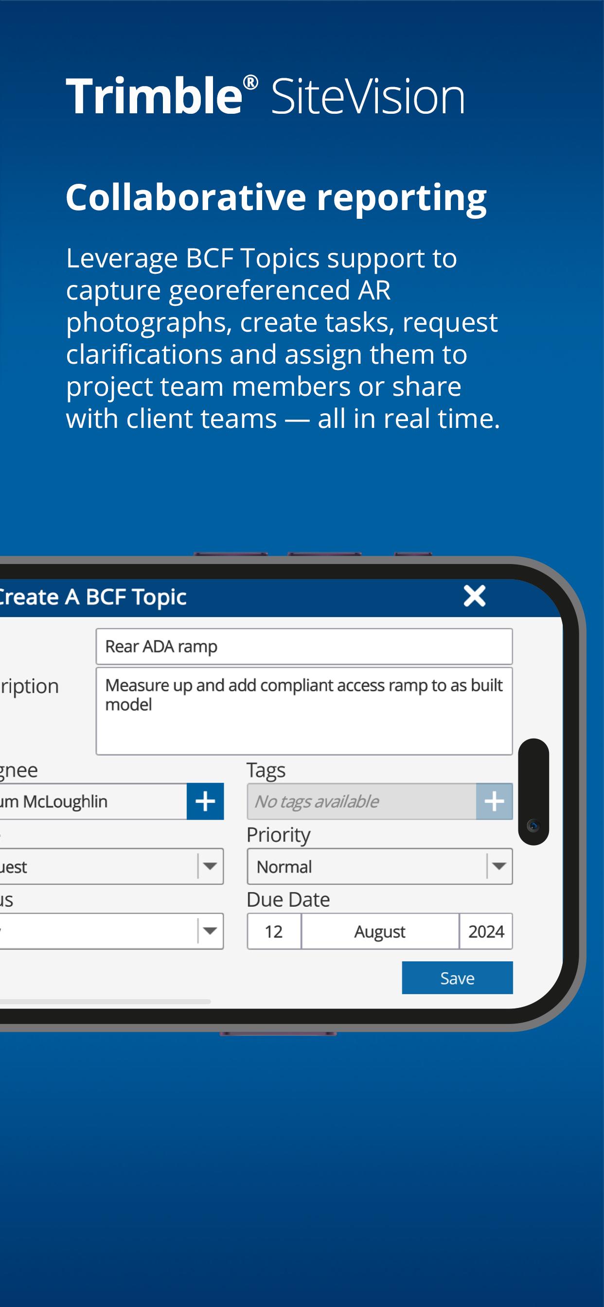
• Capture issues - take augmented reality site photos to clearly communicate issues & share them with industry standard BCF Topic support.
• Cloud enabled collaboration - share project data with Trimble Connect, cloud-based common data environment and collaboration platform.
• Measurements - measure and record progress and as-built information such as positions, lengths, and areas
• Offline support - work offline then sync later to Trimble Connect
• Supports a wide range of industry workflows and data formats:
– common BIM data via Trimble Connect - IFC, NWD/NWC, RVT, SKP, DWG, TRB, Tekla
– CAD data from Trimble Business enter, Civil3D, OpenRoads, Novapoint, LandXML
– GIS data via Trimble Maps and OGC Web Feature Services
• Support for precision GNSS workflows enabled by Trimble RTX and VRS services or internet base stations for global correction service coverage
Note: This app supports the Trimble HPS2 handle and Trimble Catalyst DA2 GNSS receiver to deliver high precision GNSS workflows. To use these accessories you need a Trimble SiteVision Pro or Trimble Catalyst subscription.
To purchase a Trimble HPS2 handle or Trimble Catalyst DA2 GNSS receiver contact your local Trimble distributor. For help or further information about Trimble SiteVision, and to find your nearest stockist, visit Trimble SiteVision
Last updated on Feb 28, 2025
• 3D Scan setting to improve scan quality by reducing capture range
• 3D Scans are automatically published and viewable in Trimble Connect and are visible within the TRCPS map view
• BCF Topics are visible within the AR/plan view for easy navigation and can be viewed and edited in the field
• Lines & Areas app now features open Polyline or closed Area measurement options
Latest Version
![]() 2025.10.7104
2025.10.7104
Uploaded by
Paulo Ricardo
Requires Android
Android 9.0+
Available on
![]()
Category
Report


Discover what you want easier, faster and safer.

Trimble SiteVision
2025.10.7104 by Trimble Inc.
Feb 28, 2025