下載 APKPure App
可在安卓獲取Noakhali district,Map,village的歷史版本
這個應用程序包含諾阿卡利縣等信息諾阿卡利地圖,村莊等。
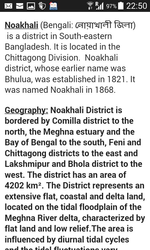
This app aontain Noakhali zilla information followed by (Bengali: নোয়াখালী জিলা)[1] is a district in South-eastern Bangladesh. It is located in the Chittagong Division. Noakhali district, whose earlier name was Bhulua, was established in 1821. It was named Noakhali in 1868.Noakhali District is bordered by Comilla district to the north, the Meghna estuary and the Bay of Bengal to the south, Feni and Chittagong districts to the east and Lakshmipur and Bhola district to the west. The district has an area of 4202 km². The District represents an extensive flat, coastal and delta land, located on the tidal floodplain of the Meghna River delta, characterized by flat land and low relief.The area is influenced by diurnal tidal cycles and the tidal fluctuations vary depending on seasons, being pronounced during the monsoon season. Around Noakhali on three sides is an alluvial plain that is annually inundated and fertilized by silt deposits from the Meghna estuary.The swift currents that course down from the Himalayas bring a rich bath of fertile silt, when it reaches the Bay of Bengal, settles along the coast, gradually forming new land called "
By installing this app you agree to the following privacy policies:
'http://www.appsgeyser.com/privacy/app/'
'http://www.oneaudience.com/privacy/'
Last updated on 2019年01月06日
Minor bug fixes and improvements. Install or update to the newest version to check it out!


Noakhali district,Map,village
0.4 by yeasin arafat
2019年01月06日